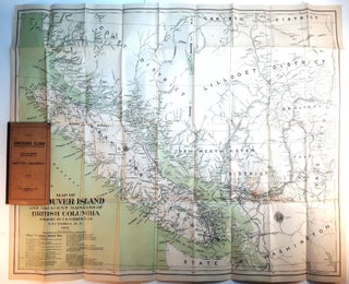
MAP OF VANCOUVER ISLAND AND ADJACENT MAINLAND OF BRITISH COLUMBIA. 1912.
Victoria, BC: T.N. Hibben & Co., 1912. Folding map, 79 x 74.5 cm, folded into thick card wrappers with black cloth spine, 19 x 10 cm. Beautiful map of Vancouver Island, New Westminster District, Coast District, Yale District, Lillooet District, Cariboo District, & part of Northern Washington State.; Cape Scott..... More